Downtown Road Closures for Blink Light Festival Start Thursday Evening
Oct 10, 2017
CINCINNATI – A half dozen roads from The Banks to Over-the-Rhine will be closed at various times for Blink Cincinnati beginning at 7:00 p.m. this Thursday, Oct. 12, through early morning Monday, Oct. 16.
Most of the closures will take place in the evenings when the light, art and projection-mapping part of the festival takes place. Daytime events also are scheduled at Piatt Park in the Central Business District and Washington Park in OTR.
The festival, which is free to attend, will span 20 city blocks and is expected to draw 500,000. It includes hospitality areas and live music performances in open-air venues primarily along or adjacent to the Cincinnati Bell Connector streetcar route. Streetcar service will continue on its normal operating schedule during the festival.
Law enforcement officials will be stationed throughout the festival area to help maintain safety and at each venue to direct pedestrians and keep traffic moving.
Sidewalks will remain open throughout the festival area as the event is designed to encourage attendees to walk from venue to venue. Pedestrians may be directed to walk to the other side of a street to use an adjacent sidewalk in a few locations where equipment is set up.
Commuters and pedestrians are encouraged to use caution while traveling in the area.
Please note: Local access will be allowed for residents and businesses at every closure.
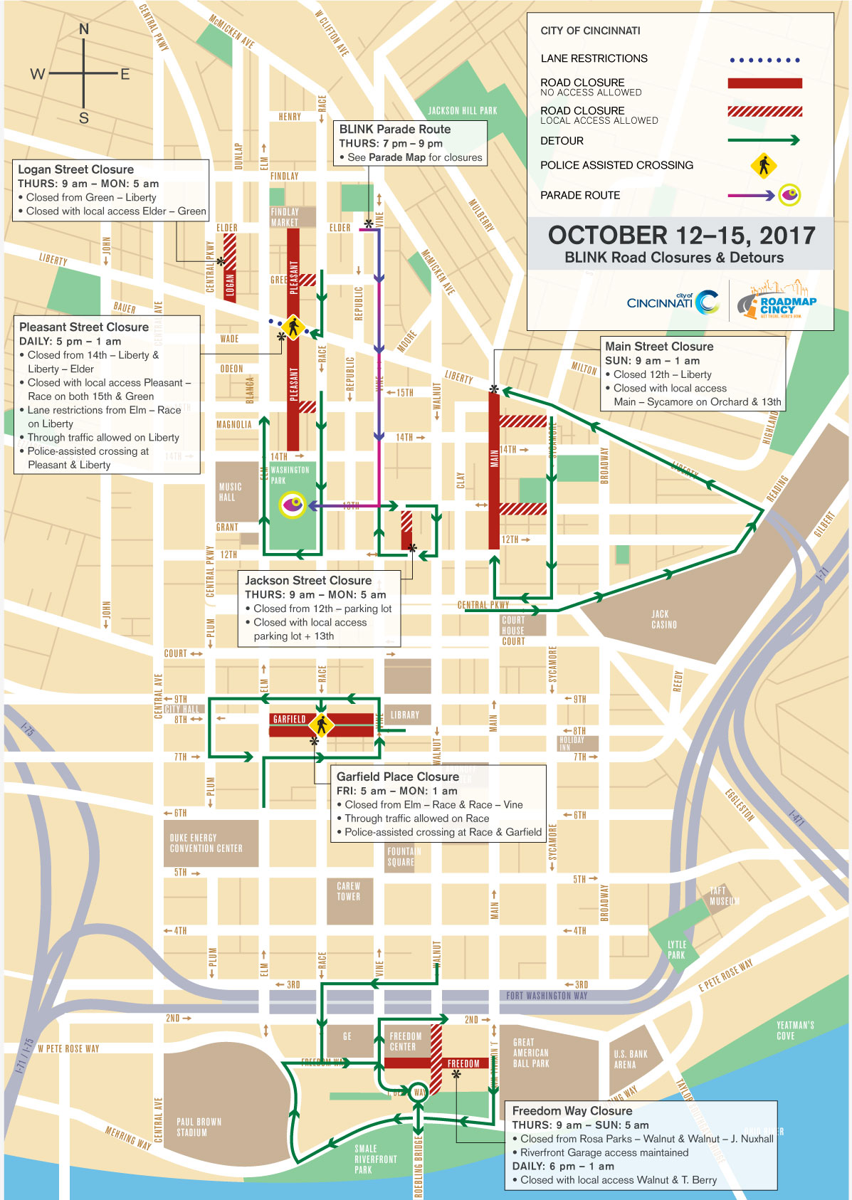
The following lists closures by area or event, and time frames. Please see the maps below for detours and other details.
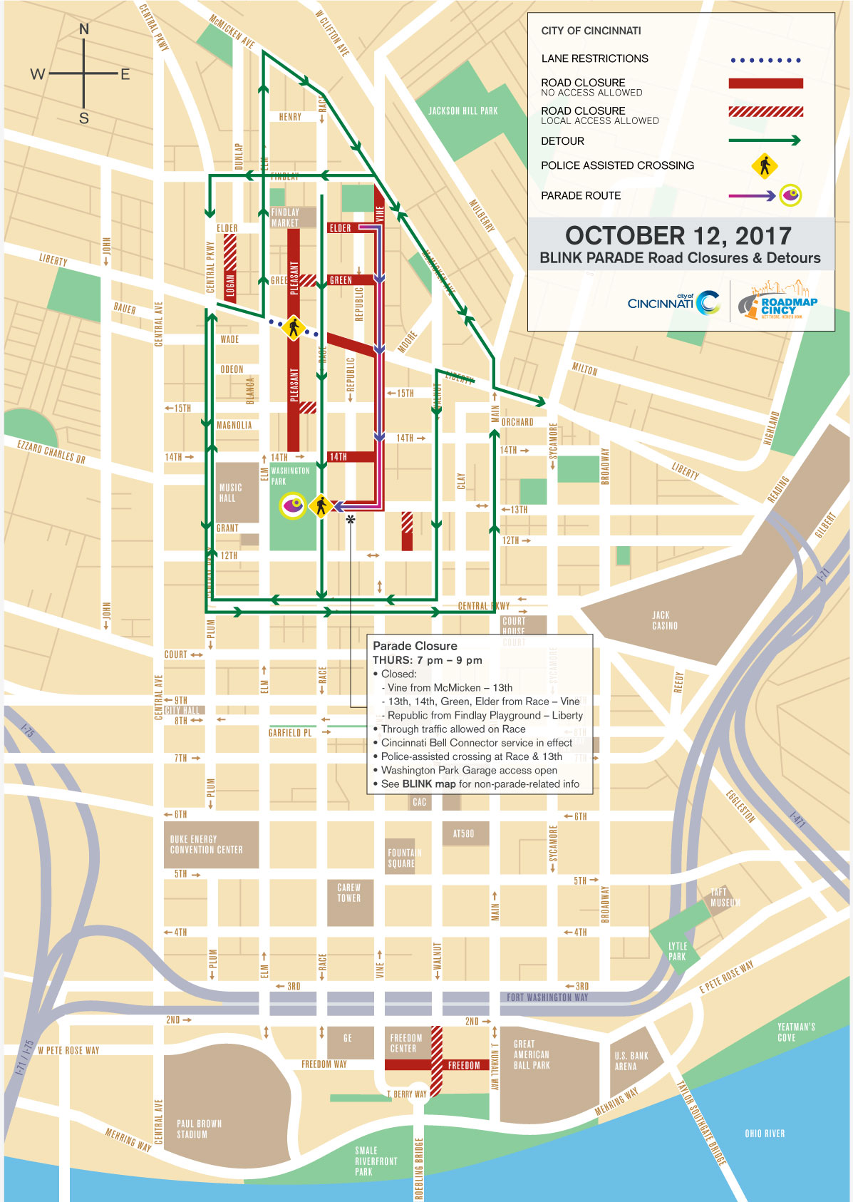
Event Parade
- Vine Street will be closed between McMicken Avenue and 13th Street from approximately 7:00 p.m. to 9:00 p.m. Thursday, Oct. 12, to accommodate parade participants. In addition, Elder, Green, 14th and 13th streets will be closed to through traffic between Race and Vine streets.
The Banks
- Freedom Way will be closed between Rosa Parks Street (Vine Street) and Joe Nuxhall Way (Main Street) from 9:00 a.m. Thursday, Oct. 12, until 5:00 a.m. Sunday, Oct. 15.
- Through traffic will be allowed during the day via Marian Spencer Way (Walnut Street).
Central Business District/Piatt Park
- Garfield Place will be closed eastbound and westbound between Vine and Elm streets from 5:00 a.m. Friday, Oct. 13, until 1:00 a.m. Monday, Oct. 16.
- Police will flag through the intersection of Race and Garfield.
Over-the-Rhine
- Jackson Street will be closed between 12th and 13th streets from 9:00 a.m. Thursday, Oct. 12, until 5:00 a.m. Monday, Oct. 16.
- Pleasant Street will be closed from 14th Street north to Elder Street at Findlay Market from 5:00 p.m. to 1:00 a.m. daily during the event, Oct. 12 – 16.
- Through traffic will be allowed on Liberty Street with lane restrictions depending on crowd size.
- Police will flag through the intersection.
- Logan Street will be closed between Liberty and Elder from 9:00 a.m. Thursday, Oct. 12, until 5:00 a.m. Monday, Oct. 16.
For more information about the festival, visit www.BlinkCincinnati.com.
Posted below are maps featuring specific road closures and detours for the Blink Parade and the overall Blink Cincinnati festival. Click on the hyperlinked names for downloadable full-service versions of the respective maps.